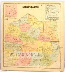
MISPILLION. KENT CO. DEL.
- Philadelphia: Pomeroy & Beers, 1868.
- 15 5/8" x 14 1/2"
- Single sheet
Price: $76.00 other currencies
Order Nr. 93343
Map of Mispillion, Kent County, Delaware. Map contains inset maps and directories of businesses in Vernon and Farmington. Map scale 1 inch to the mile and inset maps 40 rods to the inch. This map has been removed from a incomplete copy of Beers' 1868 Atlas of the State of Delaware (page 57), which contains "actual surveys by and under the direction of D.G. Beers." Daniel G. Beers came from a family of atlas publishers. He and his brother Silas operated in Philadelphia, the center of atlas publication in the United States, until he moved to New York City in 1868. Beers and his family produced detailed maps of many Northeastern states, cities, and counties until the 1880s, when the United States began to systematize mapping practices, and mapmaking moved out of private publication (Mano, Jo Margaret). Engraved by Worley & Bracher of Philadelphia and printed by Fred Bourquin. Maps in color.
Related Books